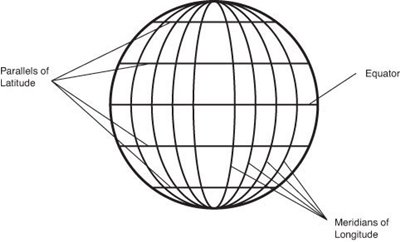
 Determining precise positions on Earth requires the use of three basic geographic parameters: latitude, longitude and elevation. These parameters are not very easy to determine and require accurate measurement procedures and state-of-the-art equipments.
Longitude specifies the east-west position of a particular point on Earth where an observer is located. Just like latitude, longitude is expressed in angular measurements, often in degrees, minutes and seconds and is denoted by the Greek letter lambda (λ). This geographic coordinate is often referenced to meridians or the great circles passing along the north and south poles. Cartographers and navigators use different references for measuring longitude.
The accepted worldwide reference as the zero meridian or the zero degrees longitude is the Prime Meridian or more popularly known as the Greenwich Meridian, which is the meridian that passes through the Royal Observatory in Greenwich, England. Longitudes indicated in published maps and international references systems are angular measurements located east or west of the Prime Meridian. Eastward measurements begin from zero degrees up to 180 degrees. Westward measurements take negative angular values from the Prime Meridian.
Like other geographic parameters, longitude is always used in conjunction with latitude to provide the best approximation of position on the surface of the Earth and to allow safe navigation.
