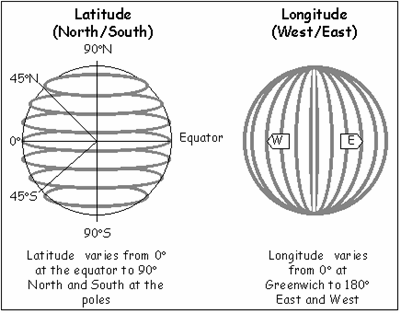
 Two different numbers, namely the Latitude and the Longitude, usually characterize various locations on Earth. This helps people in determining specific locations on the map, and the respective distances between two points on the Earth.
Visualize the Earth as a see through sphere. Looking through the Earth one may observe an equatorial plane, with a middle point, or center of the sphere or Earth. In order to indicate the Latitude of any point on the top of the Earth, you can draw a line from the center of the sphere to the point of interest.
Thus, the angle of the point with respect to the equator is the Latitude. North of the equator, the latitude is positive, south of the equator, the latitude is negative. Thus, it is because of this angle, along with the longitude, that reading the map has become easier and more effective to use.
No longer are the days in which maps would roughly present distances based on mere perception, and not clear measurement. With the Longitude and Latitude, one will be able to specifically pinpoint with only slight error a certain point on Earth. This has been a helpful yet innovative tool over the years.
